Mexico: Tropical Storm Vance weakens off the Pacific coast, bringing rain and dangerous surf
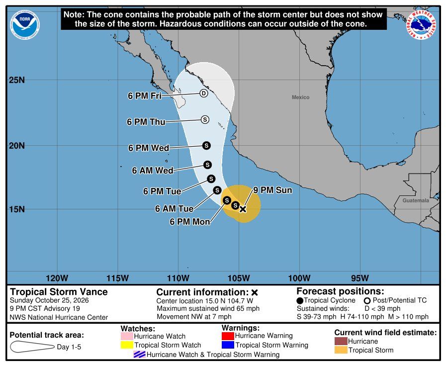
Miami, Florida — Tropical Storm Vance weakened on Sunday off Mexico's Pacific coast, with maximum sustained winds of 70 mph (110 km/h), and is expected to keep losing strength over the next few days, according to Advisory Number 18 from the United States National Hurricane Center (NHC), issued at 3:00 p.m. Central Mexico time.
At that time, Vance's center was located near latitude 14.9 north and longitude 104.2 west, about 315 miles (510 km) west-southwest of Acapulco and about 285 miles (455 km) south of Manzanillo. It was moving toward the north-northwest at 7 mph, with a minimum central pressure of 994 millibars. No coastal watches or warnings are in effect, although the NHC urged interests along southwestern Mexico to keep monitoring the system.
The forecast calls for a northwestward or west-northwestward motion at a slower forward speed over the next few days, followed by a turn toward the north around midweek. Wind shear and relatively dry air will keep weakening Vance, which could become post-tropical in about 96 hours and degenerate into a remnant low by late in the week.
Although the direct threat to Mexico is easing as the track shifts westward, away from the coast, the NHC warns that rainfall from Vance will keep affecting parts of western Mexico for much of the week: 2 to 4 inches of rain are expected, with isolated totals of up to 7 inches, across Colima, Nayarit and Sinaloa, as well as western Michoacán, Jalisco and Durango, which may produce flooding and mudslides, especially in areas of steep terrain.
In addition, swells generated by Vance will affect the coasts of southern and southwestern Mexico over the next several days and are likely to cause life-threatening surf and rip current conditions, according to the NHC.
Photo: National Hurricane Center (NHC) / NOAA
Source: National Hurricane Center (NHC)